Alpine Tundra Zone
General description
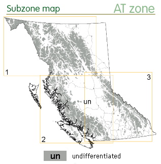
The AT zone occurs at higher elevations in mountainous areas throughout BC. It is the largest zone in BC, covering 17.5 million ha or 18.4% of the province. The AT zone occurs above the MH zone in coastal BC, the ESSF zone in eastern BC and the SWB zone in northern BC.
The AT zone has a very harsh, cold, snowy and windy climate with a mean annual temperature of -1.9 °C. It is not just the cold which limits tree growth but the duration and intensity of the warm season. The AT zone lacks a warm season (i.e. mean temperature of the warmest month is < 10°C) and has a very short frost-free period (temperatures are above 0°C for only 7-11 months of the year).
The zone can be divided into three regions which vary considerably in precipitation and continentality: coastal, northern interior, and southern interior. It is generally drier and colder in the northern interior region and milder and snowier in the coastal region. In the southern interior region, snowfall is lower in the lee of the Coast Mountains and in the Kootneys, and higher in interior wet belt. Overall the precipitation ranges from 700-3000 mm, most of which falls as snow.
Subzone and site classifications for the AT zone are currently being developed by BC MOF.
View detailed maps and climate data for the AT zone.
Forest description
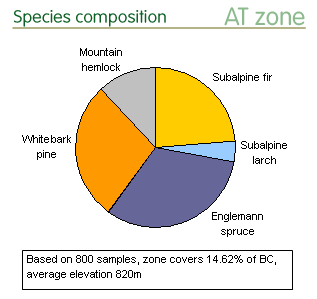
 While the zone is considered non-forested, trees in stunted or krummholz form do occur at lower elevations on sites with shallow or early melting snow. Mountain hemlock, subalpine fir, white bark pine, subalpine larch and Englemann spruce are the major timber line species; yellow-cedar and white spruce are less common. These tree species are found on 9.9% of the land in the AT zone. Alpine vegetation (cushion or trailing shrubs, herbs, bryophytes, and lichens), which is scarce and generally patchy, occurs at mid to lower elevations on only 2.1% of the land. The remaining land (87.7%) lacks vegetation and is covered by rock, snow and ice.
Conservation status
Protected areas
Total protected area coverage in the AT zone is the highest of all zones. The protected areas are both large and well distributed among the northern, coastal and interior areas. The AT zone ranks third after the MH and SWB zones for the percentage of large (>250ha) protected areas (75%), and second after the CWH zone for total number of protected areas (> 200).
- View protected area distribution on the zone map.
Species representation in protected areas
The tree species are expected to be well protected at threshold values throughout the three regions of the AT zone.
- See “BC Tree Species Reports” webpages to view tree species range maps with protected areas, or range maps with conservation statistics by BGC zones.
Conservation priorities
No genetic resource conservation concerns were identified for the tree species in the AT zone.
References
The general ecology information presented here has been summarized from the BC MOF brochure and the BC MOF publication Meidinger, D. and J. Pojar. 1991. Ecosystems of British Columbia. BC Ministry of Forests, Victoria, BC. 330pp.
The in situ conservation statisitics are from Hamann, A., Smets, P., Aitken, S. N. and Yanchuk, A. D. 2005. An ecogeographic framework for in situ conservation of forest trees in British Columbia. Can. J. For. Res. 35:2553-2561. View online resources.
The in situ conservation status summaries are from C. Chourmouzis, A.D. Yanchuk, A. Hamann, P. Smets, and S.N. Aitken. 2009. Forest Tree Genetic Conservation Status Report 1: In situ conservation status of all indigenous BC species. Centre for Forest Conservation Genetics, Forest Genetics Council of BC, and BC Ministry of Forests and Range, Forest Science Program, Victoria, BC Technical Report 053. www.for.gov.bc.ca/hfd/pubs/Docs/Tr/Tr053.htm. View online resources.
